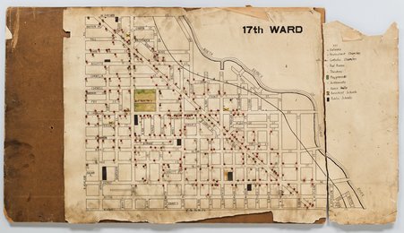
Title:Chicago Commons Map of 17th Ward, ChicagoDescription:Map of 17th Ward, Chicago, Illinois, 1910. Map includes public and private schools, Protestant and Roman Catholic churches, public parks, and other local institutions.Date Depicted:1910Creator:Chicago CommonsCreator Role:creatorPhysical Format:mapsCopyright Notice:No Known CopyrightCredit Line:Chicago History Museum, ICHi-074325Storage Location:Chicago Commons Association recordsMax Pixels - Width:6563Max Pixels - Height:3773Help improve this content
Your download will start shortly, please do not navigate away from this page until the download prompt has appeared. Doing so may cause your download to be interrupted.